IMAGES TAKEN NEAR TO
Mill Lane, BEDFORD, MK43 7AT
Introduction
This page details the photographs taken nearby to Mill Lane, MK43 7AT by members of the Geograph project.
The Geograph project started in 2005 with the aim of publishing, organising and preserving representative images for every square kilometre of Great Britain, Ireland and the Isle of Man.

There are currently over 7.5m images from over14,400 individuals and you can help contribute to the project by visiting https://www.geograph.org.uk
Image Map
Images are licensed for reuse under creativecommons.org/licenses/by-sa/2.0
Notes
- Clicking on the map will re-center to the selected point.
- The higher the marker number, the further away the image location is from the centre of the postcode.
Image Listing (37 Images Found)
Images are licensed for reuse under creativecommons.org/licenses/by-sa/2.0
Image
Details
Distance
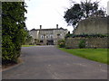
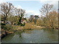
1
Odell Mill
The first reference to a mill in Odell was made in 1086 but it is apparently not possible to establish that the mill in question was on this particular site. However milling took place on this site for at least some of the intervening period until the early C20.
Image: © David Kemp
Taken: 29 Mar 2014
0.02 miles
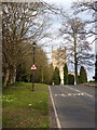
3
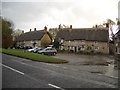
The Bell Public House at Odell
The Bell is a popular public house in the High Street near the north-eastern edge of Odell & Harrold Country Park. It backs on to the River Great Ouse and
is a Grade II listed building of 17th century origins,
extended and modernised.
Image: © Nigel Stickells
Taken: 20 Nov 2006
0.02 miles
4
Footbridge over River Great Ouse at Odell
Image: © PAUL FARMER
Taken: 27 Feb 2016
0.02 miles
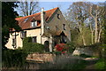
5
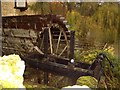
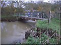
Waterwheel & Sluice Gate at Odell Mill
The waterwheel, long disused, is undershot. It can be seen 'over the garden wall' from the bridleway adjacent to the former mill house situated beside the River Great Ouse at Odell.
Image: © Nigel Stickells
Taken: 20 Nov 2006
0.03 miles
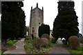
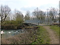
6
Footbridge over River Great Ouse at Odell
This bridge carries a bridleway over the River Great Ouse across the fields between Odell and the Carlton/Felmersham road. The bridleway is accessed from the green in front of The Bell Public House and passes by the former Odell Mill, the millpond of which is on the immediate far side of this bridge.
Image: © Nigel Stickells
Taken: 20 Nov 2006
0.03 miles
7
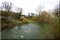
River Great Ouse at Odell
Taken looking downstream from the footbridge across the river.
Image: © David Kemp
Taken: 17 Mar 2014
0.08 miles