IMAGES TAKEN NEAR TO
Ridgway Road, BEDFORD, MK43 0YA
Introduction
This page details the photographs taken nearby to Ridgway Road, MK43 0YA by members of the Geograph project.
The Geograph project started in 2005 with the aim of publishing, organising and preserving representative images for every square kilometre of Great Britain, Ireland and the Isle of Man.

There are currently over 7.5m images from over14,400 individuals and you can help contribute to the project by visiting https://www.geograph.org.uk
Image Map
Images are licensed for reuse under creativecommons.org/licenses/by-sa/2.0
Notes
- Clicking on the map will re-center to the selected point.
- The higher the marker number, the further away the image location is from the centre of the postcode.
Image Listing (6 Images Found)
Images are licensed for reuse under creativecommons.org/licenses/by-sa/2.0
Image
Details
Distance
1
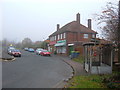
Brogborough Shops
A view of the shops on the main road (A421 - Bedford Road) in Brogborough.
Image: © Mr Biz
Taken: 20 Nov 2010
0.12 miles
2
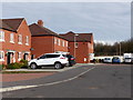
Bowling Close, Brogborough, looking north
Image: © Rob Purvis
Taken: 9 Mar 2018
0.16 miles
3
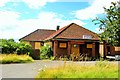
Brogborough Club
Brogborough Sports and Social Club was built in 1938 and became the centre of village life. The closure of the neighbouring brickyards and the change in the demography of the area, with more commuter housing, led to a decline in use and the club finally closed in 2007.
For more pictures and information see www.28dayslater.co.uk/brogborough-sports-and-social-club-brogborough-august-2013.t84609
Image: © Tiger
Taken: 20 Jul 2008
0.17 miles
5
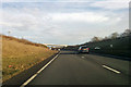
A421 towards Bedford
A cutting through Brogborough Hill.
Image: © Robin Webster
Taken: 9 Dec 2017
0.23 miles
6
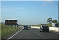
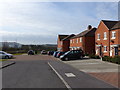
A sign to make kids smile
New section of the A421, approaching the interchange with the M1.
Image: © Mr Ignavy
Taken: 28 Oct 2011
0.25 miles