IMAGES TAKEN NEAR TO
Turnpike Road, BEDFORD, MK43 0XB
Introduction
This page details the photographs taken nearby to Turnpike Road, MK43 0XB by members of the Geograph project.
The Geograph project started in 2005 with the aim of publishing, organising and preserving representative images for every square kilometre of Great Britain, Ireland and the Isle of Man.

There are currently over 7.5m images from over14,400 individuals and you can help contribute to the project by visiting https://www.geograph.org.uk
Image Map
Images are licensed for reuse under creativecommons.org/licenses/by-sa/2.0
Notes
- Clicking on the map will re-center to the selected point.
- The higher the marker number, the further away the image location is from the centre of the postcode.
Image Listing (17 Images Found)
Images are licensed for reuse under creativecommons.org/licenses/by-sa/2.0
Image
Details
Distance
1
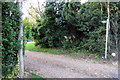
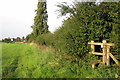
Footpath to Church End
This footpath actually goes up someone's drive.
Image: © Philip Jeffrey
Taken: 1 Sep 2012
0.05 miles
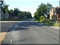
2
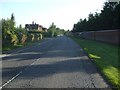
A4012 looking NNE
Looking towards Ridgmont from Crawley Lodge
Image: © Barry Ephgrave
Taken: 25 Jul 2009
0.06 miles
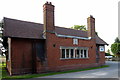
4
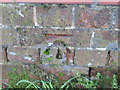
Ordnance Survey Cut Mark
This mark can be found on a roadside wall near Crawley Lodge.
For more detail see : http://www.bench-marks.org.uk/bm46483
Image: © Peter Wood
Taken: 29 Nov 2012
0.12 miles
5
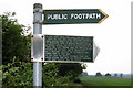
Note on footpath sign about a WW2 bomber that crashed nearby
Image: © Philip Jeffrey
Taken: 20 Jun 2013
0.13 miles
6
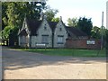
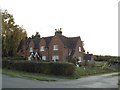
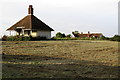
Crawley Lodge
Gate house at one entrance to Woburn Safari Park
Image: © Barry Ephgrave
Taken: 25 Jul 2009
0.16 miles
8
A4012 looking SW
A4012 looking towards Woburn from Crawley Lodge
Image: © Barry Ephgrave
Taken: 25 Jul 2009
0.19 miles