IMAGES TAKEN NEAR TO
Lanchester Road, BEDFORD, MK43 0TA
Introduction
This page details the photographs taken nearby to Lanchester Road, MK43 0TA by members of the Geograph project.
The Geograph project started in 2005 with the aim of publishing, organising and preserving representative images for every square kilometre of Great Britain, Ireland and the Isle of Man.

There are currently over 7.5m images from over14,400 individuals and you can help contribute to the project by visiting https://www.geograph.org.uk
Image Map
Images are licensed for reuse under creativecommons.org/licenses/by-sa/2.0
Notes
- Clicking on the map will re-center to the selected point.
- The higher the marker number, the further away the image location is from the centre of the postcode.
Image Listing (4 Images Found)
Images are licensed for reuse under creativecommons.org/licenses/by-sa/2.0
Image
Details
Distance
1
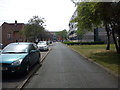
The Drive
Looking along The Drive. All the property here is owned by Cranfield University and used as student accommodation. The wooden panelled block on the right is part of Chilver Hall, and the Brick one at the end of the road part of Lanchester Hall.
Image: © Robert Kerr
Taken: 25 May 2011
0.04 miles
2
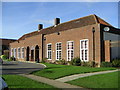
Lanchester Hall, Cranfield University
A reception building on the Cranfield University campus for the student accommodation.
Image: © Mr Biz
Taken: 29 Oct 2006
0.14 miles
3
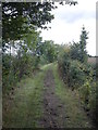
Shire Lane
Looking north along Shire Lane. Shire Lane is a public bridleway which runs along the border between Bedfordshire and Buckinghamshire.
Image: © Robert Kerr
Taken: 31 Aug 2011
0.15 miles
4

Bus at Cranfield University
In fading light, a bus pauses briefly near the main gate of Cranfield University's campus before returning to Bedford. The road junction here, between Prince Philip Avenue (behind the bus) and College Road (out of the frame to the right), forms a small triangle which enables buses to turn round easily. The housing visible behind the bus appears to date back to the campus' former life as an RAF base.
Image: © Richard Vince
Taken: 6 Mar 2010
0.20 miles