IMAGES TAKEN NEAR TO
Church Street, BEDFORD, MK43 0RJ
Introduction
This page details the photographs taken nearby to Church Street, MK43 0RJ by members of the Geograph project.
The Geograph project started in 2005 with the aim of publishing, organising and preserving representative images for every square kilometre of Great Britain, Ireland and the Isle of Man.

There are currently over 7.5m images from over14,400 individuals and you can help contribute to the project by visiting https://www.geograph.org.uk
Image Map
Images are licensed for reuse under creativecommons.org/licenses/by-sa/2.0
Notes
- Clicking on the map will re-center to the selected point.
- The higher the marker number, the further away the image location is from the centre of the postcode.
Image Listing (39 Images Found)
Images are licensed for reuse under creativecommons.org/licenses/by-sa/2.0
Image
Details
Distance
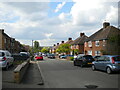
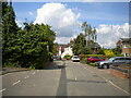
2
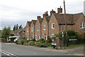
Cottages in Church Street, Lidlington
Taken at the junction with Oak Gardens (left) and St Margarets Close (right).
Image: © David Kemp
Taken: 5 Sep 2009
0.03 miles
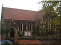
6
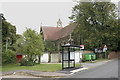
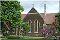
St Margaret, Lidlington
Surrounded by a bus shelter, garages and a pair of wheelie bins, the north-western aspect of the church is not its most scenic. The church was built in 1886 and replaced another, now demolished church in the gridsquare.
Image: © David Kemp
Taken: 5 Sep 2009
0.07 miles
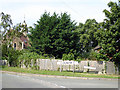
9
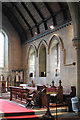
St Margaret, Lidlington, Beds - Chancel
Image: © John Salmon
Taken: 15 May 2004
0.07 miles