IMAGES TAKEN NEAR TO
Beckerings Park, BEDFORD, MK43 0RD
Introduction
This page details the photographs taken nearby to Beckerings Park, MK43 0RD by members of the Geograph project.
The Geograph project started in 2005 with the aim of publishing, organising and preserving representative images for every square kilometre of Great Britain, Ireland and the Isle of Man.

There are currently over 7.5m images from over14,400 individuals and you can help contribute to the project by visiting https://www.geograph.org.uk
Image Map
Images are licensed for reuse under creativecommons.org/licenses/by-sa/2.0
Notes
- Clicking on the map will re-center to the selected point.
- The higher the marker number, the further away the image location is from the centre of the postcode.
Image Listing (3 Images Found)
Images are licensed for reuse under creativecommons.org/licenses/by-sa/2.0
Image
Details
Distance
1
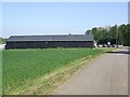
Business Units, Beckerings Park
This dark building is part of a group of newly created business units at Manor House Farm. The sign on the entrance to the lane says "ARC Progress" whom I think may let the properties.
Image: © Rob Farrow
Taken: 2 May 2007
0.02 miles
2
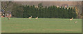
On the Alert
These deer were aware we were about being slightly up wind of them but we were shielded by a tree line and noise from the M1. There was a whole herd on an adjoining field, but too far away to even consider getting the camera out.
Image: © Dennis simpson
Taken: 2 Mar 2008
0.16 miles