IMAGES TAKEN NEAR TO
Marston Hill, BEDFORD, MK43 0QH
Introduction
This page details the photographs taken nearby to Marston Hill, MK43 0QH by members of the Geograph project.
The Geograph project started in 2005 with the aim of publishing, organising and preserving representative images for every square kilometre of Great Britain, Ireland and the Isle of Man.

There are currently over 7.5m images from over14,400 individuals and you can help contribute to the project by visiting https://www.geograph.org.uk
Image Map
Images are licensed for reuse under creativecommons.org/licenses/by-sa/2.0
Notes
- Clicking on the map will re-center to the selected point.
- The higher the marker number, the further away the image location is from the centre of the postcode.
Image Listing (6 Images Found)
Images are licensed for reuse under creativecommons.org/licenses/by-sa/2.0
Image
Details
Distance
1
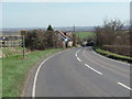
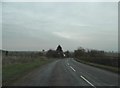
East from Cranfield
The road heading east from Cranfield to Wootton. In the distance can be seen the chimneys of the Stewartby brickworks.
Image: © Richard Schmidt
Taken: 16 Mar 2007
0.04 miles
3
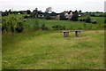
Marston Hill, near Cranfield
A view of Marston Hill, looking eastwards over Marston Vale.
Image: © Malc McDonald
Taken: 20 Oct 2012
0.08 miles
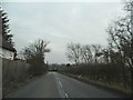
4
Marston Hill east of Cranfield
Compare with the first photo taken in this square. The light wasn't so good this time but I can't allow for bad weather. http://www.geograph.org.uk/photo/368198
Image: © David Howard
Taken: 12 Mar 2017
0.09 miles
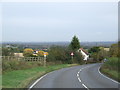
5
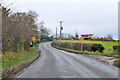
Marston Hill entering Cranfield 30 limit
Image: © Robin Webster
Taken: 5 Dec 2021
0.10 miles