IMAGES TAKEN NEAR TO
Station Road, BEDFORD, MK43 0PJ
Introduction
This page details the photographs taken nearby to Station Road, MK43 0PJ by members of the Geograph project.
The Geograph project started in 2005 with the aim of publishing, organising and preserving representative images for every square kilometre of Great Britain, Ireland and the Isle of Man.

There are currently over 7.5m images from over14,400 individuals and you can help contribute to the project by visiting https://www.geograph.org.uk
Image Map
Images are licensed for reuse under creativecommons.org/licenses/by-sa/2.0
Notes
- Clicking on the map will re-center to the selected point.
- The higher the marker number, the further away the image location is from the centre of the postcode.
Image Listing (14 Images Found)
Images are licensed for reuse under creativecommons.org/licenses/by-sa/2.0
Image
Details
Distance
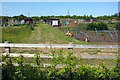
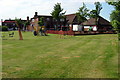
2
Jubilee Cottage Allotments
Just opposite the Jubilee Cottages outside of Marston Moretaine
Image: © Mr Biz
Taken: 20 Nov 2010
0.09 miles
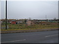
3
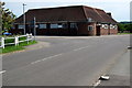
Row of houses and club
A row of houses probably built by the brick company or local council with an adjacent working man's club.
Image: © Andrew Tatlow
Taken: 16 Mar 2008
0.10 miles
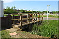
7
Stream at the edge of Marston Moretaine
Image: © Philip Jeffrey
Taken: 7 Jun 2013
0.15 miles
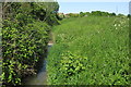
8
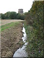
Drain at Marston Moretaine
A drainage channel at Marston Moretaine in Bedfordshire. In the background is the tower of St. Mary's Church.
Image: © Malc McDonald
Taken: 20 Oct 2012
0.16 miles
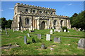
9
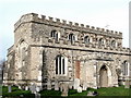
St. Mary's, Marston Moretaine, Bedfordshire
The tower is separate from the rest of the church and is out of picture.
Image: © nick macneill
Taken: 19 May 1994
0.20 miles