IMAGES TAKEN NEAR TO
Hookes Meadow, BEDFORD, MK43 0GQ
Introduction
This page details the photographs taken nearby to Hookes Meadow, MK43 0GQ by members of the Geograph project.
The Geograph project started in 2005 with the aim of publishing, organising and preserving representative images for every square kilometre of Great Britain, Ireland and the Isle of Man.

There are currently over 7.5m images from over14,400 individuals and you can help contribute to the project by visiting https://www.geograph.org.uk
Image Map
Images are licensed for reuse under creativecommons.org/licenses/by-sa/2.0
Notes
- Clicking on the map will re-center to the selected point.
- The higher the marker number, the further away the image location is from the centre of the postcode.
Image Listing (10 Images Found)
Images are licensed for reuse under creativecommons.org/licenses/by-sa/2.0
Image
Details
Distance
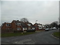
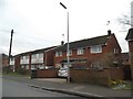
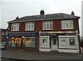
1
Cranfield High Street
The high street in the village of Cranfield, Bedfordshire.
Image: © Malc McDonald
Taken: 20 Oct 2012
0.06 miles
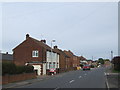
3
The Cross Keys, Cranfield
The Cross Keys pub in Cranfield, Bedfordshire.
Image: © Malc McDonald
Taken: 20 Oct 2012
0.11 miles
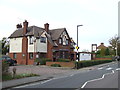
7
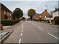
Cranfield
The main road running through Cranfield village.
Image: © Richard Schmidt
Taken: 12 Nov 2006
0.17 miles
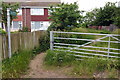
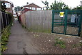
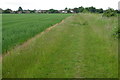
9
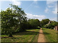
Path leading out of Cranfield
Path leading from Cranfield towards Marston Thrift
Image: © Mike Wilkinson
Taken: 2 May 2009
0.24 miles