IMAGES TAKEN NEAR TO
Bedford Road, BEDFORD, MK43 0EX
Introduction
This page details the photographs taken nearby to Bedford Road, MK43 0EX by members of the Geograph project.
The Geograph project started in 2005 with the aim of publishing, organising and preserving representative images for every square kilometre of Great Britain, Ireland and the Isle of Man.

There are currently over 7.5m images from over14,400 individuals and you can help contribute to the project by visiting https://www.geograph.org.uk
Image Map
Images are licensed for reuse under creativecommons.org/licenses/by-sa/2.0
Notes
- Clicking on the map will re-center to the selected point.
- The higher the marker number, the further away the image location is from the centre of the postcode.
Image Listing (7 Images Found)
Images are licensed for reuse under creativecommons.org/licenses/by-sa/2.0
Image
Details
Distance
2
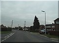
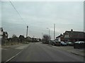
East End, Cranfield
Where rural life and village life meet. A couple of silos in the middle of a row of houses.
Image: © Richard Schmidt
Taken: 12 Nov 2006
0.17 miles
3
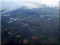
Cranfield Airport from the air
The airport http://www.cranfieldairport.eu/ is in the lower half of the photo, with Milton Keynes in the distance.
Image: © Thomas Nugent
Taken: 13 Oct 2012
0.18 miles
5
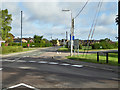
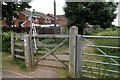
Broad Green
The name of the road with the cyclist, and also of a triangular hedged green, one corner of which is through the gate towards the right.
Image: © Robin Webster
Taken: 4 Sep 2016
0.20 miles
6
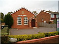
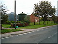
Baptist Church
The Baptist church, East End, Cranfield.
Image: © Richard Schmidt
Taken: 12 Nov 2006
0.21 miles