IMAGES TAKEN NEAR TO
Folly Farm, BEDFORD, MK43 0DL
Introduction
This page details the photographs taken nearby to Folly Farm, MK43 0DL by members of the Geograph project.
The Geograph project started in 2005 with the aim of publishing, organising and preserving representative images for every square kilometre of Great Britain, Ireland and the Isle of Man.

There are currently over 7.5m images from over14,400 individuals and you can help contribute to the project by visiting https://www.geograph.org.uk
Image Map
Images are licensed for reuse under creativecommons.org/licenses/by-sa/2.0
Notes
- Clicking on the map will re-center to the selected point.
- The higher the marker number, the further away the image location is from the centre of the postcode.
Image Listing (12 Images Found)
Images are licensed for reuse under creativecommons.org/licenses/by-sa/2.0
Image
Details
Distance
1
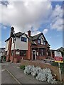
The Cross Keys public house Cranfield
Image: © Ryan Griffiths
Taken: 12 Mar 2022
0.04 miles
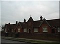
2
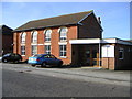
Cranfield Methodist Church
Meeting Hall & Methodist Church located in Cranfield along the main road.
Image: © Mr Biz
Taken: 29 Oct 2006
0.05 miles
3
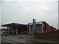
Petrol station on High Street, Cranfield
Image: © David Howard
Taken: 12 Mar 2017
0.05 miles
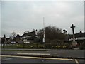
4
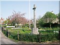
War Memorial, Cranfield
Situated on the corner of the High Street and Church Walk.
Image: © N Avery
Taken: 15 Apr 2007
0.16 miles
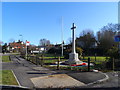
6
The green and war memorial at Cranfield
Image: © David Howard
Taken: 12 Mar 2017
0.17 miles
8
Round the back
Looking across at the back of the high street in Cranfield from Lodge Lane.
Image: © Richard Schmidt
Taken: 12 Nov 2006
0.18 miles
9
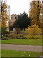
Cranfield Church
The parish church, Cranfield.
Image: © Richard Schmidt
Taken: 12 Nov 2006
0.18 miles
10
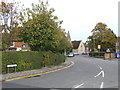
Court Road, Cranfield
Court Road in the village of Cranfield, Bedfordshire.
Image: © Malc McDonald
Taken: 20 Oct 2012
0.19 miles