IMAGES TAKEN NEAR TO
College Road, BEDFORD, MK43 0AH
Introduction
This page details the photographs taken nearby to College Road, MK43 0AH by members of the Geograph project.
The Geograph project started in 2005 with the aim of publishing, organising and preserving representative images for every square kilometre of Great Britain, Ireland and the Isle of Man.

There are currently over 7.5m images from over14,400 individuals and you can help contribute to the project by visiting https://www.geograph.org.uk
Image Map
Images are licensed for reuse under creativecommons.org/licenses/by-sa/2.0
Notes
- Clicking on the map will re-center to the selected point.
- The higher the marker number, the further away the image location is from the centre of the postcode.
Image Listing (7 Images Found)
Images are licensed for reuse under creativecommons.org/licenses/by-sa/2.0
Image
Details
Distance
1
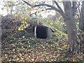
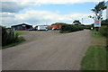
Shelter on the edge of Cranfield Airport
Cranfield Airport started life as an RAF base during world war II and various signs of its previous use still remain. This old shelter can be found alongside a public footpath on the northwest corner of the airport.
Image: © Robert Kerr
Taken: 2 Nov 2011
0.11 miles
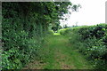
4

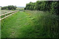
Footpath to Cranfield by the airfield
Image: © Philip Jeffrey
Taken: 25 Jun 2013
0.14 miles