IMAGES TAKEN NEAR TO
White Horse Drive, MILTON KEYNES, MK4 2HU
Introduction
This page details the photographs taken nearby to White Horse Drive, MK4 2HU by members of the Geograph project.
The Geograph project started in 2005 with the aim of publishing, organising and preserving representative images for every square kilometre of Great Britain, Ireland and the Isle of Man.

There are currently over 7.5m images from over14,400 individuals and you can help contribute to the project by visiting https://www.geograph.org.uk
Image Map
Images are licensed for reuse under creativecommons.org/licenses/by-sa/2.0
Notes
- Clicking on the map will re-center to the selected point.
- The higher the marker number, the further away the image location is from the centre of the postcode.
Image Listing (25 Images Found)
Images are licensed for reuse under creativecommons.org/licenses/by-sa/2.0
Image
Details
Distance
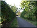
6
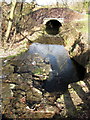
Small bridge under White Horse Drive
Image: © Philip Jeffrey
Taken: 24 Feb 2012
0.16 miles
7
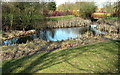
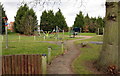
Footbridge and lake in the Emerson Valley linear park
Image: © Philip Jeffrey
Taken: 24 Feb 2012
0.17 miles
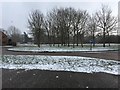
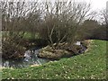
9
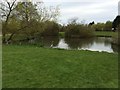
Pond in Emerson Valley Park
With Grey Heron
Image: © Philip Jeffrey
Taken: 1 May 2016
0.17 miles
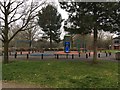
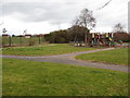
10
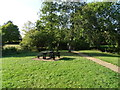
Picnic area and path beside National Cycle Route 51, Milton Keynes
Image: © JThomas
Taken: 21 Sep 2019
0.18 miles