IMAGES TAKEN NEAR TO
Cropton Rise, MILTON KEYNES, MK4 2GJ
Introduction
This page details the photographs taken nearby to Cropton Rise, MK4 2GJ by members of the Geograph project.
The Geograph project started in 2005 with the aim of publishing, organising and preserving representative images for every square kilometre of Great Britain, Ireland and the Isle of Man.

There are currently over 7.5m images from over14,400 individuals and you can help contribute to the project by visiting https://www.geograph.org.uk
Image Map
Images are licensed for reuse under creativecommons.org/licenses/by-sa/2.0
Notes
- Clicking on the map will re-center to the selected point.
- The higher the marker number, the further away the image location is from the centre of the postcode.
Image Listing (12 Images Found)
Images are licensed for reuse under creativecommons.org/licenses/by-sa/2.0
Image
Details
Distance
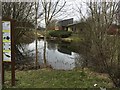
1
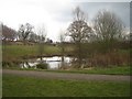
Park pond one
Dark February day - perhaps not the best view of one of the ponds here.
Image: © Malcolm Campbell
Taken: 19 Feb 2009
0.16 miles
3

Morrisons Filling Station in the Westcroft District Centre
Image: © Steve Daniels
Taken: 3 Nov 2014
0.19 miles
5
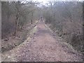
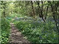
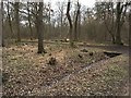
Into the trees
Wide path up into Howe Park Wood.
Image: © Malcolm Campbell
Taken: 19 Feb 2009
0.19 miles
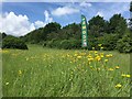
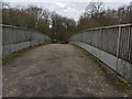
7
Howe Park Wood
Though the Parks Trust seem to be managing most of the wood out of it.
Image: © Philip Jeffrey
Taken: 9 Mar 2018
0.22 miles
9
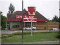
KFC Restaurant
Drive-through fast-food restaurant in Westcroft.
Image: © Mr Biz
Taken: 27 Jul 2006
0.24 miles