IMAGES TAKEN NEAR TO
Taunton Deane, MILTON KEYNES, MK4 2BL
Introduction
This page details the photographs taken nearby to Taunton Deane, MK4 2BL by members of the Geograph project.
The Geograph project started in 2005 with the aim of publishing, organising and preserving representative images for every square kilometre of Great Britain, Ireland and the Isle of Man.

There are currently over 7.5m images from over14,400 individuals and you can help contribute to the project by visiting https://www.geograph.org.uk
Image Map (Loading...)


Getting Data...Please wait
Leaflet Map data © OpenStreetMap
Images are licensed for reuse under creativecommons.org/licenses/by-sa/2.0
Notes
- Clicking on the map will re-center to the selected point.
- The higher the marker number, the further away the image location is from the centre of the postcode.
Image Listing (24 Images Found)
Images are licensed for reuse under creativecommons.org/licenses/by-sa/2.0
Image
Details
Distance
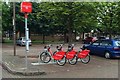
3

Blackmoor Gate, Furzton
Blackmoor Gate leads of Fulmer Street; the junction with Northleigh and Challacombe is ahead (Milton Keynes Council appears to have consulted a map of the Exmoor area as their inspiration here). The bus stop is served by route 440 which provides six journeys on weekdays to Central Milton Keynes.
Image: © Stephen McKay
Taken: 10 May 2023
0.12 miles
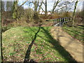
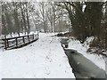
5
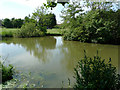
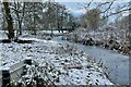
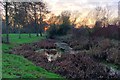
Loughton Valley Park, Emerson Valley
Part of the linear park which follows the course of the old Shenley Brook.
Image: © Cameraman
Taken: 28 Jun 2010
0.13 miles
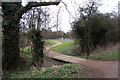
9
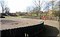
Children's playground in the linear park
Image: © Philip Jeffrey
Taken: 24 Feb 2012
0.16 miles
10
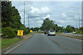
A421 Standing Way, Milton Keynes, heading north-east
Or H8 under the Milton Keynes road grid numbering system. The roundabout ahead is the intersection with V3.
Image: © Robin Webster
Taken: 9 Jun 2019
0.17 miles