IMAGES TAKEN NEAR TO
High Street, BEDFORD, MK42 9XU
Introduction
This page details the photographs taken nearby to High Street, MK42 9XU by members of the Geograph project.
The Geograph project started in 2005 with the aim of publishing, organising and preserving representative images for every square kilometre of Great Britain, Ireland and the Isle of Man.

There are currently over 7.5m images from over14,400 individuals and you can help contribute to the project by visiting https://www.geograph.org.uk
Image Map
Images are licensed for reuse under creativecommons.org/licenses/by-sa/2.0
Notes
- Clicking on the map will re-center to the selected point.
- The higher the marker number, the further away the image location is from the centre of the postcode.
Image Listing (66 Images Found)
Images are licensed for reuse under creativecommons.org/licenses/by-sa/2.0
Image
Details
Distance
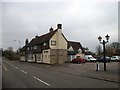
1
The Swan, Elstow
A 16th century Grade II listed public house. http://www.bedfordshire.gov.uk/CommunityAndLiving/ArchivesAndRecordOffice/CommunityArchives/Elstow/SwanPublicHouse.aspx?ContensisTextOnly=text
Image: © Robin Drayton
Taken: 16 May 2008
0.00 miles
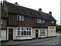
2
Former coaching Inn The White Lion High Street Elstow
Image: © PAUL FARMER
Taken: 23 Jan 2010
0.01 miles
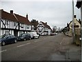
3
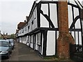
High Street, Elstow
A long range of half-timbered buildings, part of which was the White Lion coaching inn in times past.
Image: © M J Richardson
Taken: 29 Apr 2010
0.01 miles
5
Swan Public House High Street, Elstow
This old public house is Grade II listed it was formerly The Star and White Swan, it was believed to have started life as a cottage in 1611
Image: © PAUL FARMER
Taken: 23 Jan 2010
0.02 miles
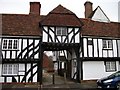
6
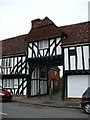
Timber framed archway, Elstow
This archway, known locally as The Jetty, use to be a coaching inn called The White Lion and was a stopping point for horse drawn coaches on the route between Bedford and London.
Image: © Robin Drayton
Taken: 16 May 2008
0.02 miles
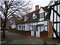
7
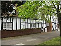
Bunyans Mead
Looking westwards, out to the Wilstead Road, from this group of nicely kept black and white houses.
Image: © M J Richardson
Taken: 29 Apr 2010
0.03 miles
9
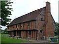
Moot Hall, Elstow
An information board states:
Moot Hall is a timber framed building constructed in the late 15th century with red brick infilling and a clay roof. The upper floor is jettied on three sides supported by diagonal 'dragon beams' projecting at the two western corners. Originally it consisted of four bays but a further bay and external brick chimney were added to the eastern end in the late 16th century. Six shops once occupied the western part of the ground floor. The open upper hall running the full length of the building was originally used as a court and meeting room. During the 19th century the hall was used as a place of worship by non-conformists and as a school room. Moot Hall is now a museum containing both a collection of 16th and 17th century furniture and items relating to the life and works of John Bunyan who was born in Elstow parish and lived there for part of his life.
http://www.discoverbedfordshire.co.uk/article.php?id=91&issueopen=2
Image: © Robin Drayton
Taken: 15 May 2008
0.03 miles
10
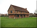
Moot Hall Elstow
Built in the 15th century partly to serve as a market-house, the hall had shops on the ground floor. The building was extended, probably in the late 15th century, adding two more shop bays and two rooms suitable for living in - these were probably used to accommodate important visitors to the nearby Abbey.
Image: © PAUL FARMER
Taken: 23 Jan 2010
0.03 miles