IMAGES TAKEN NEAR TO
Gostwick Road, BEDFORD, MK42 9XD
Introduction
This page details the photographs taken nearby to Gostwick Road, MK42 9XD by members of the Geograph project.
The Geograph project started in 2005 with the aim of publishing, organising and preserving representative images for every square kilometre of Great Britain, Ireland and the Isle of Man.

There are currently over 7.5m images from over14,400 individuals and you can help contribute to the project by visiting https://www.geograph.org.uk
Image Map
Images are licensed for reuse under creativecommons.org/licenses/by-sa/2.0
Notes
- Clicking on the map will re-center to the selected point.
- The higher the marker number, the further away the image location is from the centre of the postcode.
Image Listing (16 Images Found)
Images are licensed for reuse under creativecommons.org/licenses/by-sa/2.0
Image
Details
Distance
4
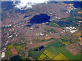
Bedford from the air
Looking north over Elstow and the A421.
Image: © Thomas Nugent
Taken: 9 May 2011
0.14 miles
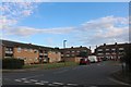
6
Houses on Mile Road, Bedford
At the corner of Lancaster Avenue.
Image: © Robin Webster
Taken: 9 Dec 2017
0.15 miles
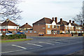
8
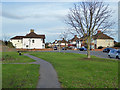
Small green, Bedford
Bounded by Mile Road, Harewood Road and Lancaster Avenue.
Image: © Robin Webster
Taken: 9 Dec 2017
0.18 miles
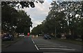
9
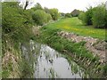
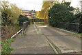
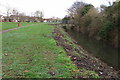
Stream at Elstow
As seen from the bridge on Wilstead Road.
Image: © M J Richardson
Taken: 29 Apr 2010
0.19 miles