IMAGES TAKEN NEAR TO
Ampthill Road, BEDFORD, MK42 9RH
Introduction
This page details the photographs taken nearby to Ampthill Road, MK42 9RH by members of the Geograph project.
The Geograph project started in 2005 with the aim of publishing, organising and preserving representative images for every square kilometre of Great Britain, Ireland and the Isle of Man.

There are currently over 7.5m images from over14,400 individuals and you can help contribute to the project by visiting https://www.geograph.org.uk
Image Map
Images are licensed for reuse under creativecommons.org/licenses/by-sa/2.0
Notes
- Clicking on the map will re-center to the selected point.
- The higher the marker number, the further away the image location is from the centre of the postcode.
Image Listing (16 Images Found)
Images are licensed for reuse under creativecommons.org/licenses/by-sa/2.0
Image
Details
Distance
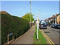
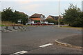
3

Lynton Grove at the junction of Ampthill Road
Image: © David Howard
Taken: 1 Sep 2021
0.10 miles

5
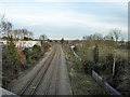
Bletchley - Bedford line
Looking towards Bedford from the Ampthill Road bridge.
Image: © Robin Webster
Taken: 9 Dec 2017
0.15 miles
6

Bedford - Bletchley line
Looking south, Kempston Hardwick next stop.
Image: © Robin Webster
Taken: 9 Dec 2017
0.16 miles
7

Lynton Grove at the junction of Ampthill Road
Image: © David Howard
Taken: 1 Sep 2021
0.17 miles
8
Elstow Road passes under a low railway bridge
Image: © Colin Pyle
Taken: 13 May 2022
0.18 miles
9
Roundabout on Abbeyfields, Bedford
Looking towards West End.
Image: © David Howard
Taken: 1 Sep 2024
0.21 miles
10

Path from Ampthill Road to Elstow Road, Bedford
It starts off between fenced car dealers compounds.
Image: © Robin Webster
Taken: 9 Dec 2017
0.21 miles