IMAGES TAKEN NEAR TO
Althorpe Street, BEDFORD, MK42 9HF
Introduction
This page details the photographs taken nearby to Althorpe Street, MK42 9HF by members of the Geograph project.
The Geograph project started in 2005 with the aim of publishing, organising and preserving representative images for every square kilometre of Great Britain, Ireland and the Isle of Man.

There are currently over 7.5m images from over14,400 individuals and you can help contribute to the project by visiting https://www.geograph.org.uk
Image Map
Images are licensed for reuse under creativecommons.org/licenses/by-sa/2.0
Notes
- Clicking on the map will re-center to the selected point.
- The higher the marker number, the further away the image location is from the centre of the postcode.
Image Listing (48 Images Found)
Images are licensed for reuse under creativecommons.org/licenses/by-sa/2.0
Image
Details
Distance
1
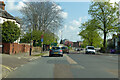
A5141 Ampthill Road, Bedford
Towards the town centre.
Image: © Robin Webster
Taken: 2 May 2021
0.07 miles
2
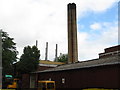
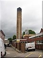
South Wing, Bedford Hospital
The large boilerhouse chimney that served the four old oil-fired boilers is unused since they were replaced by modern gas-fired boilers, which only need the three small and much less obtrusive chimneys. Savings from the £1 million project are estimated to be £450000 pa, with boiler efficiency increased from 58% to 80%, and carbon emissions are significantly reduced. http://www.etaenergy.co.uk/
Image: © M J Richardson
Taken: 13 Jun 2011
0.08 miles
3
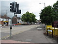
Ampthill Road
The A6, looking southwest, from its junction with Britannia Road [A5141].
Image: © M J Richardson
Taken: 13 Jun 2011
0.08 miles
4
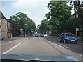
South End
The A6 as it passes through South End, Bedford.
Image: © Richard Schmidt
Taken: 9 Jun 2007
0.08 miles
5
Bedford Hospital, South Wing boilerhouse
The large boilerhouse chimney that served the four old oil-fired boilers is unused since they were replaced by modern gas-fired boilers, which only need the three small and much less obtrusive chimneys. Savings from the £1 million project are estimated to be £450000 pa, with boiler efficiency increased from 58% to 80%, and carbon emissions are significantly reduced.http://www.etaenergy.co.uk/ .
Image: © M J Richardson
Taken: 13 Jun 2011
0.09 miles
6
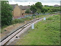
The line to Bletchley
Looking southeast from the A6 Ampthill Road at Bedford St John's Station, the single track line from Bedford to Bletchley.
Image: © M J Richardson
Taken: 13 Jun 2011
0.12 miles
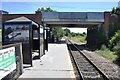
8
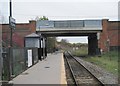
Bedford St. Johns railway station
Opened in 1984 by British Rail on the Bedford to Bletchley line, to replace the earlier St Johns station. View south east, just before the line swings sharply right towards Kempston and Bletchley.
Image: © Nigel Thompson
Taken: 13 Nov 2010
0.14 miles
9
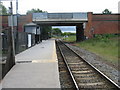
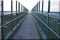
Bedford St John's Station
Looking southeast towards Bletchley. The bridge carries the A6 [Ampthill Road] over the single platform unmanned station.
Image: © M J Richardson
Taken: 13 Jun 2011
0.14 miles
10
The new Bedford St. Johns Station
The new Bedford St. Johns Station was opened in May 1984 when the old station of the same name was closed. Trains on the Marston Vale Line were diverted to terminate at the main Bedford Station, so this new station was built to provide access in the St. Johns area. The old station was on the Bedford to Cambridge line and had been a terminus since closure of the Cambridge section.
Image: © Bob Walters
Taken: 28 Jul 2018
0.14 miles