IMAGES TAKEN NEAR TO
Ampthill Road, MK42 9HB
Introduction
This page details the photographs taken nearby to Ampthill Road, MK42 9HB by members of the Geograph project.
The Geograph project started in 2005 with the aim of publishing, organising and preserving representative images for every square kilometre of Great Britain, Ireland and the Isle of Man.

There are currently over 7.5m images from over14,400 individuals and you can help contribute to the project by visiting https://www.geograph.org.uk
Image Map
Images are licensed for reuse under creativecommons.org/licenses/by-sa/2.0
Notes
- Clicking on the map will re-center to the selected point.
- The higher the marker number, the further away the image location is from the centre of the postcode.
Image Listing (13 Images Found)
Images are licensed for reuse under creativecommons.org/licenses/by-sa/2.0
Image
Details
Distance

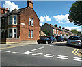
2
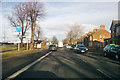
Ampthill Road (A6) Bedford
Heading into town.
Image: © Robin Webster
Taken: 9 Dec 2017
0.12 miles

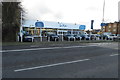
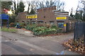
8

Sue Ryder shop on Ampthill Road, Bedford
Image: © David Howard
Taken: 30 Jan 2022
0.18 miles
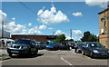
10
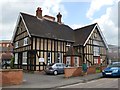
St Leonard's Church Centre - Victoria Road
The 1892 building was used as an auxiliary hospital during the First World War.
Image: © John M
Taken: 26 Jun 2016
0.24 miles