IMAGES TAKEN NEAR TO
Tewkesbury Road, BEDFORD, MK42 9GD
Introduction
This page details the photographs taken nearby to Tewkesbury Road, MK42 9GD by members of the Geograph project.
The Geograph project started in 2005 with the aim of publishing, organising and preserving representative images for every square kilometre of Great Britain, Ireland and the Isle of Man.

There are currently over 7.5m images from over14,400 individuals and you can help contribute to the project by visiting https://www.geograph.org.uk
Image Map (Loading...)


Getting Data...Please wait
Leaflet Map data © OpenStreetMap
Images are licensed for reuse under creativecommons.org/licenses/by-sa/2.0
Notes
- Clicking on the map will re-center to the selected point.
- The higher the marker number, the further away the image location is from the centre of the postcode.
Image Listing (9 Images Found)
Images are licensed for reuse under creativecommons.org/licenses/by-sa/2.0
Image
Details
Distance
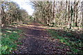
2
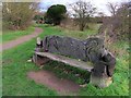
Carved bench by the footpath towards Harrowden
It's a shame the otters have been defaced, literally.
Image: © Philip Jeffrey
Taken: 9 Dec 2018
0.12 miles

7
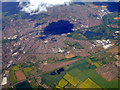
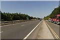
Bedford from the air
Looking north over Elstow and the A421.
Image: © Thomas Nugent
Taken: 9 May 2011
0.19 miles