IMAGES TAKEN NEAR TO
Holme Street, BEDFORD, MK42 9AU
Introduction
This page details the photographs taken nearby to Holme Street, MK42 9AU by members of the Geograph project.
The Geograph project started in 2005 with the aim of publishing, organising and preserving representative images for every square kilometre of Great Britain, Ireland and the Isle of Man.

There are currently over 7.5m images from over14,400 individuals and you can help contribute to the project by visiting https://www.geograph.org.uk
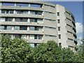
Image Map
Images are licensed for reuse under creativecommons.org/licenses/by-sa/2.0
Notes
- Clicking on the map will re-center to the selected point.
- The higher the marker number, the further away the image location is from the centre of the postcode.
Image Listing (117 Images Found)
Images are licensed for reuse under creativecommons.org/licenses/by-sa/2.0
Image
Details
Distance
1
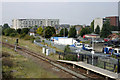
Bedford St Johns station
This unstaffed station comprises a single platform and a small shelter, and is on the Bedford Midland - Bletchley line. It opened in May 1984, replacing another station with the same name which was sited not far away in Station Road. This enabled trains from Bletchley to make connections at Bedford's main line station instead of terminating in a separate station on the edge of town.
Image: © David Kemp
Taken: 19 Sep 2009
0.05 miles
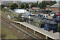
3
Bedford St John's Station
Looking towards Bedford mainline station from the unmanned station on the Bedford-Bletchley branchline.
Image: © M J Richardson
Taken: 13 Jun 2011
0.07 miles

5
Bedford St Johns station
This unstaffed station comprises a single platform and a small shelter, and is on the Bedford Midland - Bletchley line. It opened in May 1984, replacing another station with the same name which was sited not far away in Station Road. This enabled trains from Bletchley to make connections at Bedford's main line station instead of terminating in a separate station on the edge of town.
Image: © David Kemp
Taken: 19 Sep 2009
0.08 miles
6
Borough Hall
Curved concrete at the corner of Prebend Street and Cauldwell Street.
Image: © Thomas Nugent
Taken: 17 May 2010
0.09 miles
7
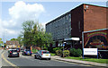
Cauldwell Street
The building on the right is Bedford College Sixth Form & University Centre.
Image: © Thomas Nugent
Taken: 17 May 2010
0.09 miles
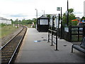
8
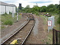
View from the end of the platform
Looking towards Bedford mainline station from the north end of Bedford StJohn's station.
Image: © M J Richardson
Taken: 13 Jun 2011
0.09 miles
9
Borough Hall
Striking architecture at the Prebend Street side of the building. Still known locally as County Hall.
Image: © Thomas Nugent
Taken: 17 May 2010
0.11 miles
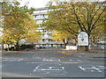
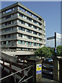
10

The Heights and Meridian House, Bedford
Image: © David Howard
Taken: 1 Sep 2021
0.11 miles