IMAGES TAKEN NEAR TO
Harrow Close, BEDFORD, MK42 9AR
Introduction
This page details the photographs taken nearby to Harrow Close, MK42 9AR by members of the Geograph project.
The Geograph project started in 2005 with the aim of publishing, organising and preserving representative images for every square kilometre of Great Britain, Ireland and the Isle of Man.

There are currently over 7.5m images from over14,400 individuals and you can help contribute to the project by visiting https://www.geograph.org.uk
Image Map
Images are licensed for reuse under creativecommons.org/licenses/by-sa/2.0
Notes
- Clicking on the map will re-center to the selected point.
- The higher the marker number, the further away the image location is from the centre of the postcode.
Image Listing (20 Images Found)
Images are licensed for reuse under creativecommons.org/licenses/by-sa/2.0
Image
Details
Distance
1
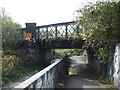
Railway bridge over path, Bedford
This path follows the north bank of the River Great Ouse, although the river isn't visible in this image. Here, the path passes beneath a railway bridge, with limited headroom. The headroom on the left-hand side of the wall is 5 feet 8 inches. The sign for the right-hand side is concealed behind foliage, but headroom on this side is 6 feet and 3 inches.
Image: © Malc McDonald
Taken: 20 Oct 2012
0.06 miles
2
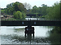
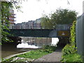
Railway bridges over the Great Ouse
Just upriver from Prebend Street road bridge.
Image: © Thomas Nugent
Taken: 17 May 2010
0.14 miles
3
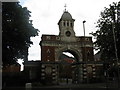
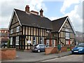
Britannia Iron Works
Ornate entrance to what was a huge Victorian foundry, dating from 1859 and with a claim to fame that it was visited by Garibaldi in 1864. The foundry closed in 1993, the works in 1998, and the site has been cleared and replaced by houses.
Image: © M J Richardson
Taken: 13 Jun 2011
0.16 miles
5
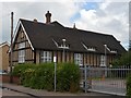
St Leonard's Church Centre - Victoria Road
The 1892 building was used as an auxiliary hospital during the First World War.
Image: © John M
Taken: 26 Jun 2016
0.18 miles
6
St Leonard's Church Centre - Victoria Road
The 1892 building was used as an auxiliary hospital during the First World War.
Image: © John M
Taken: 26 Jun 2016
0.18 miles
8
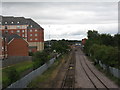
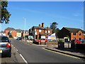
Looking northwest from Cauldwell Street
Along the branch line from Milton Keynes towards Bedford mainline station.
Image: © M J Richardson
Taken: 13 Jun 2011
0.19 miles
10
Riverside path, Bedford
A path alongside the River Great Ouse in Bedford. Here, the path passes beneath a railway line. The sign on the bridge shows that the headroom is just 4 feet and 9 inches.
Image: © Malc McDonald
Taken: 20 Oct 2012
0.20 miles