IMAGES TAKEN NEAR TO
Hillgrounds Road, BEDFORD, MK42 8QP
Introduction
This page details the photographs taken nearby to Hillgrounds Road, MK42 8QP by members of the Geograph project.
The Geograph project started in 2005 with the aim of publishing, organising and preserving representative images for every square kilometre of Great Britain, Ireland and the Isle of Man.

There are currently over 7.5m images from over14,400 individuals and you can help contribute to the project by visiting https://www.geograph.org.uk
Image Map
Images are licensed for reuse under creativecommons.org/licenses/by-sa/2.0
Notes
- Clicking on the map will re-center to the selected point.
- The higher the marker number, the further away the image location is from the centre of the postcode.
Image Listing (9 Images Found)
Images are licensed for reuse under creativecommons.org/licenses/by-sa/2.0
Image
Details
Distance
1

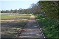
Egglestone Close, Kempston
View of Egglestone Close from Hillgrounds Road.
Image: © N Avery
Taken: 24 Jan 2022
0.08 miles
2
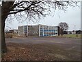
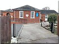
Kempston Challenger Academy, Kempston
Kempston Challenger Academy (now closed), formerly Robert Bruce Middle School. View from Hillgrounds Road.
Image: © N Avery
Taken: 24 Jan 2022
0.12 miles
4
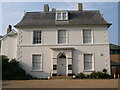
Kempston Manor, Manor Drive, Kempston
A Grade II listed building.
Image: © N Avery
Taken: 16 Oct 2005
0.22 miles
7
Catholic Church of Our Lady of Ransom, Hillgrounds Road, Kempston
Image: © N Avery
Taken: 24 Jan 2022
0.23 miles
8
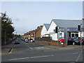
King Street, Kempston, Bedford
King Street in Kempston, a suburb of Bedford. The blue sign next to the traffic light column indicates that King Street is a no through road.
Image: © Malc McDonald
Taken: 20 Oct 2012
0.24 miles