IMAGES TAKEN NEAR TO
Thetford Close, BEDFORD, MK42 8PF
Introduction
This page details the photographs taken nearby to Thetford Close, MK42 8PF by members of the Geograph project.
The Geograph project started in 2005 with the aim of publishing, organising and preserving representative images for every square kilometre of Great Britain, Ireland and the Isle of Man.

There are currently over 7.5m images from over14,400 individuals and you can help contribute to the project by visiting https://www.geograph.org.uk
Image Map
Images are licensed for reuse under creativecommons.org/licenses/by-sa/2.0
Notes
- Clicking on the map will re-center to the selected point.
- The higher the marker number, the further away the image location is from the centre of the postcode.
Image Listing (10 Images Found)
Images are licensed for reuse under creativecommons.org/licenses/by-sa/2.0
Image
Details
Distance
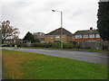
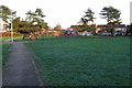
2
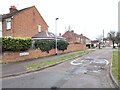
Houses at The Hornbeams
On Elstow Road, Kempston.
Image: © M J Richardson
Taken: 29 Nov 2011
0.10 miles
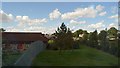
4
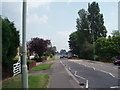
Kempston
A main road through Kempston.
Image: © Richard Schmidt
Taken: 9 Jun 2007
0.17 miles
7
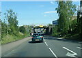
Elstow Road passes under a low railway bridge
Image: © Colin Pyle
Taken: 13 May 2022
0.23 miles
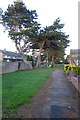
8
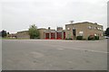
Bedfordshire & Luton Fire & Rescue Service Headquarters
Bedfordshire & Luton Fire & Rescue Service Headquarters, Southfields Road, Kempston, Bedfordshire, which includes Kempston fire station Image
Image: © Kevin Hale
Taken: 7 Oct 2007
0.24 miles
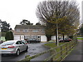
10
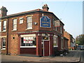
The Smiths Arms, Margetts Road, Kempston
Public House on corner of Margetts Road and Duncombe Street, Kempston, Bedford. The building was first licensed as a beer house in 1856.
Image: © N Avery
Taken: 16 Oct 2005
0.25 miles