IMAGES TAKEN NEAR TO
Thirlmere Road, BEDFORD, MK42 8HG
Introduction
This page details the photographs taken nearby to Thirlmere Road, MK42 8HG by members of the Geograph project.
The Geograph project started in 2005 with the aim of publishing, organising and preserving representative images for every square kilometre of Great Britain, Ireland and the Isle of Man.

There are currently over 7.5m images from over14,400 individuals and you can help contribute to the project by visiting https://www.geograph.org.uk
Image Map
Images are licensed for reuse under creativecommons.org/licenses/by-sa/2.0
Notes
- Clicking on the map will re-center to the selected point.
- The higher the marker number, the further away the image location is from the centre of the postcode.
Image Listing (16 Images Found)
Images are licensed for reuse under creativecommons.org/licenses/by-sa/2.0
Image
Details
Distance
5
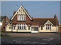
The Duke Public House, Woburn Road, Kempston
This public house was open by c.1885 when it first appears on local directories.
Image: © N Avery
Taken: 16 Oct 2005
0.14 miles
6
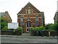
Church of God Prophecy, Bunyan Road, Kempston
Bunyan Road Church and Community Centre, now the Church of God Prophecy.
Image: © N Avery
Taken: 23 May 2006
0.15 miles
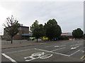
8
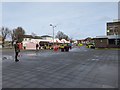
Market area outside Sainsbury's, Kempston
Image: © Rob Purvis
Taken: 26 Jan 2020
0.16 miles
9
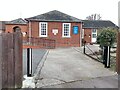
Catholic Church of Our Lady of Ransom, Hillgrounds Road, Kempston
Image: © N Avery
Taken: 24 Jan 2022
0.16 miles