IMAGES TAKEN NEAR TO
Walford Grove, BEDFORD, MK42 7GW
Introduction
This page details the photographs taken nearby to Walford Grove, MK42 7GW by members of the Geograph project.
The Geograph project started in 2005 with the aim of publishing, organising and preserving representative images for every square kilometre of Great Britain, Ireland and the Isle of Man.

There are currently over 7.5m images from over14,400 individuals and you can help contribute to the project by visiting https://www.geograph.org.uk
Image Map
Images are licensed for reuse under creativecommons.org/licenses/by-sa/2.0
Notes
- Clicking on the map will re-center to the selected point.
- The higher the marker number, the further away the image location is from the centre of the postcode.
Image Listing (22 Images Found)
Images are licensed for reuse under creativecommons.org/licenses/by-sa/2.0
Image
Details
Distance
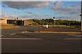
3
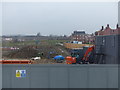
Construction work to the north of the Premier Inn at Kempston
Image: © Rob Purvis
Taken: 9 Mar 2018
0.06 miles

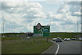
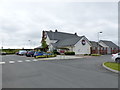
7
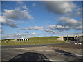
Roundabout on The Branston Way, Kempston
Image: © David Howard
Taken: 12 Mar 2017
0.12 miles
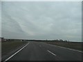
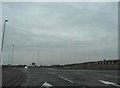
8
Roundabout on The Branston Way, Kempston
Joining the A421
Image: © David Howard
Taken: 11 Jun 2017
0.13 miles