IMAGES TAKEN NEAR TO
The Bower, BEDFORD, MK42 7GT
Introduction
This page details the photographs taken nearby to The Bower, MK42 7GT by members of the Geograph project.
The Geograph project started in 2005 with the aim of publishing, organising and preserving representative images for every square kilometre of Great Britain, Ireland and the Isle of Man.

There are currently over 7.5m images from over14,400 individuals and you can help contribute to the project by visiting https://www.geograph.org.uk
Image Map
Images are licensed for reuse under creativecommons.org/licenses/by-sa/2.0
Notes
- Clicking on the map will re-center to the selected point.
- The higher the marker number, the further away the image location is from the centre of the postcode.
Image Listing (15 Images Found)
Images are licensed for reuse under creativecommons.org/licenses/by-sa/2.0
Image
Details
Distance
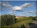
1
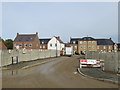
Lewis Close, Bedford
Lewis Close is part of a new housing development being built on the edge of Bedford.
Image: © Malc McDonald
Taken: 20 Oct 2012
0.06 miles
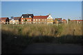
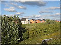
2
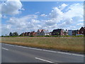
New housing estate
On the outskirts of Bedford.
Image: © Bikeboy
Taken: 27 Jun 2015
0.09 miles
4
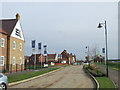
New housing, Bedford
A new housing development on the edge of Bedford.
Image: © Malc McDonald
Taken: 20 Oct 2012
0.12 miles
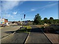
5
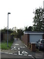
Cycle path, Bedford
A shared footpath and cycle path on the outskirts of Bedford.
Image: © Malc McDonald
Taken: 20 Oct 2012
0.13 miles
9
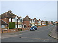
Ditmas Avenue, Bedford
Ditmas Avenue is a residential road on the outskirts of Bedford. The houses are semi-detached.
Image: © Malc McDonald
Taken: 20 Oct 2012
0.18 miles
10
New houses by The Branston Way, Kempston
Image: © David Howard
Taken: 11 Jun 2017
0.18 miles