IMAGES TAKEN NEAR TO
High Street, BEDFORD, MK42 7BT
Introduction
This page details the photographs taken nearby to High Street, MK42 7BT by members of the Geograph project.
The Geograph project started in 2005 with the aim of publishing, organising and preserving representative images for every square kilometre of Great Britain, Ireland and the Isle of Man.

There are currently over 7.5m images from over14,400 individuals and you can help contribute to the project by visiting https://www.geograph.org.uk
Image Map
Images are licensed for reuse under creativecommons.org/licenses/by-sa/2.0
Notes
- Clicking on the map will re-center to the selected point.
- The higher the marker number, the further away the image location is from the centre of the postcode.
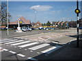
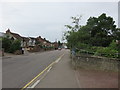
Image Listing (17 Images Found)
Images are licensed for reuse under creativecommons.org/licenses/by-sa/2.0
Image
Details
Distance
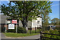
1
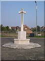
War Memorial, High Street, Kempston
The land directly behind the memorial was waiting construction of a Lidl Store. This was built and subsequently demolished.
Image: © N Avery
Taken: 16 Oct 2005
0.04 miles
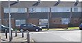
3
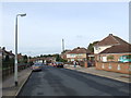
Wyatt Road, Bedford
Wyatt Road is a residential road on the outskirts of Bedford.
Image: © Malc McDonald
Taken: 20 Oct 2012
0.11 miles
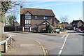
5
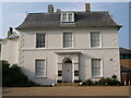
Kempston Manor, Manor Drive, Kempston
A Grade II listed building.
Image: © N Avery
Taken: 16 Oct 2005
0.18 miles