IMAGES TAKEN NEAR TO
Hummingbird Way, BEDFORD, MK42 6EU
Introduction
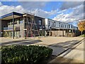
This page details the photographs taken nearby to Hummingbird Way, MK42 6EU by members of the Geograph project.
The Geograph project started in 2005 with the aim of publishing, organising and preserving representative images for every square kilometre of Great Britain, Ireland and the Isle of Man.

There are currently over 7.5m images from over14,400 individuals and you can help contribute to the project by visiting https://www.geograph.org.uk
Image Map
Images are licensed for reuse under creativecommons.org/licenses/by-sa/2.0
Notes
- Clicking on the map will re-center to the selected point.
- The higher the marker number, the further away the image location is from the centre of the postcode.
Image Listing (2 Images Found)
Images are licensed for reuse under creativecommons.org/licenses/by-sa/2.0
Image
Details
Distance
2
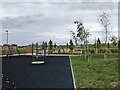
New playpark and distant houses
This park is in an area that will be developed with houses but at the time of taking the picture it was strangely located in a scrubland with roads and partially built houses nearby.
Image: © Rob Purvis
Taken: 9 Jul 2023
0.22 miles