IMAGES TAKEN NEAR TO
Roe Deer Place, BEDFORD, MK42 6EN
Introduction
This page details the photographs taken nearby to Roe Deer Place, MK42 6EN by members of the Geograph project.
The Geograph project started in 2005 with the aim of publishing, organising and preserving representative images for every square kilometre of Great Britain, Ireland and the Isle of Man.

There are currently over 7.5m images from over14,400 individuals and you can help contribute to the project by visiting https://www.geograph.org.uk
Image Map
Images are licensed for reuse under creativecommons.org/licenses/by-sa/2.0
Notes
- Clicking on the map will re-center to the selected point.
- The higher the marker number, the further away the image location is from the centre of the postcode.
Image Listing (4 Images Found)
Images are licensed for reuse under creativecommons.org/licenses/by-sa/2.0
Image
Details
Distance

3
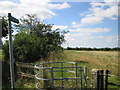
Wilstead to Houghton Conquest footpath by A6
footpath through Vicarage Farm fields
Image: © ian saunders
Taken: 26 Aug 2007
0.25 miles
4
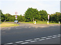
Bedford Road, Wilstead, Beds
the entrance to the village from across the A6 by-pass.
Image: © Rodney Burton
Taken: 31 May 2006
0.25 miles