IMAGES TAKEN NEAR TO
North End, BEDFORD, MK42 0XB
Introduction
This page details the photographs taken nearby to North End, MK42 0XB by members of the Geograph project.
The Geograph project started in 2005 with the aim of publishing, organising and preserving representative images for every square kilometre of Great Britain, Ireland and the Isle of Man.

There are currently over 7.5m images from over14,400 individuals and you can help contribute to the project by visiting https://www.geograph.org.uk
Image Map
Images are licensed for reuse under creativecommons.org/licenses/by-sa/2.0
Notes
- Clicking on the map will re-center to the selected point.
- The higher the marker number, the further away the image location is from the centre of the postcode.
Image Listing (9 Images Found)
Images are licensed for reuse under creativecommons.org/licenses/by-sa/2.0
Image
Details
Distance
1
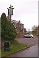
The Gate, Harrowden
Harrowden is a one street hamlet south of Bedford. John Bunyan was born here.
Image: © Ian Capper
Taken: 13 Mar 2008
0.12 miles
2
The Gate, Harrowden
The pub servicing the hamlet of Harrowden. Harrowden was with birth place of John Bunyan.
Image: © Mr Biz
Taken: 25 Apr 2008
0.12 miles
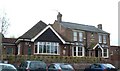
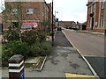
4
Shortstown Local Shop
The local shop which serves the village of Shortstown.
Image: © Mr Biz
Taken: 25 Apr 2008
0.15 miles
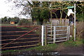
6
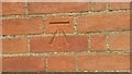
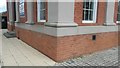
Pseudo Benchmark - Close up
Close up photo of newly cut benchmark.
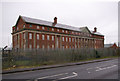
Shorts Building, Former RAF Cardington
Northwest Corner. Northern face.
Image: © Geoboy
Taken: 14 Jun 2016
0.16 miles
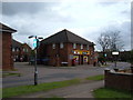
7
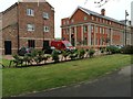
The Shorts Building, Cardington airfield
Built in 1917 (on the parapet below the front gable is inscribed MCMXVII), this asymmetric building served as a hotel for airship passengers.
Image: © Ian Capper
Taken: 13 Mar 2008
0.18 miles
9
Pseudo Benchmark
Recently cut benchmark on Shorts Building. Former RAF Cardington.
Image: © Geoboy
Taken: 14 Jun 2016
0.20 miles