IMAGES TAKEN NEAR TO
Lancaster Road, BEDFORD, MK42 0UB
Introduction
This page details the photographs taken nearby to Lancaster Road, MK42 0UB by members of the Geograph project.
The Geograph project started in 2005 with the aim of publishing, organising and preserving representative images for every square kilometre of Great Britain, Ireland and the Isle of Man.

There are currently over 7.5m images from over14,400 individuals and you can help contribute to the project by visiting https://www.geograph.org.uk
Image Map
Images are licensed for reuse under creativecommons.org/licenses/by-sa/2.0
Notes
- Clicking on the map will re-center to the selected point.
- The higher the marker number, the further away the image location is from the centre of the postcode.
Image Listing (5 Images Found)
Images are licensed for reuse under creativecommons.org/licenses/by-sa/2.0
Image
Details
Distance
1
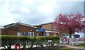
Shortstown Lower School
The lower school in the village of Shortstown.
Image: © Mr Biz
Taken: 25 Apr 2008
0.11 miles
4
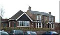
The Gate, Harrowden
The pub servicing the hamlet of Harrowden. Harrowden was with birth place of John Bunyan.
Image: © Mr Biz
Taken: 25 Apr 2008
0.22 miles
5
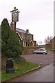
The Gate, Harrowden
Harrowden is a one street hamlet south of Bedford. John Bunyan was born here.
Image: © Ian Capper
Taken: 13 Mar 2008
0.23 miles