IMAGES TAKEN NEAR TO
Central Avenue, BEDFORD, MK42 0TS
Introduction
This page details the photographs taken nearby to Central Avenue, MK42 0TS by members of the Geograph project.
The Geograph project started in 2005 with the aim of publishing, organising and preserving representative images for every square kilometre of Great Britain, Ireland and the Isle of Man.

There are currently over 7.5m images from over14,400 individuals and you can help contribute to the project by visiting https://www.geograph.org.uk
Image Map
Images are licensed for reuse under creativecommons.org/licenses/by-sa/2.0
Notes
- Clicking on the map will re-center to the selected point.
- The higher the marker number, the further away the image location is from the centre of the postcode.
Image Listing (13 Images Found)
Images are licensed for reuse under creativecommons.org/licenses/by-sa/2.0
Image
Details
Distance
1
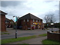
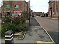
Shortstown Local Shop
The local shop which serves the village of Shortstown.
Image: © Mr Biz
Taken: 25 Apr 2008
0.10 miles
2
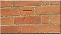
Pseudo Benchmark - Close up
Close up photo of newly cut benchmark.
Shorts Building, Former RAF Cardington
Northwest Corner. Northern face.
Image: © Geoboy
Taken: 14 Jun 2016
0.16 miles
3
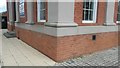
Pseudo Benchmark
Recently cut benchmark on Shorts Building. Former RAF Cardington.
Image: © Geoboy
Taken: 14 Jun 2016
0.17 miles
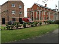
5
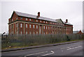
The Shorts Building, Cardington airfield
Built in 1917 (on the parapet below the front gable is inscribed MCMXVII), this asymmetric building served as a hotel for airship passengers.
Image: © Ian Capper
Taken: 13 Mar 2008
0.17 miles
7
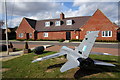
Model plane in front of the Air Cadets building
Image: © Philip Jeffrey
Taken: 3 Oct 2014
0.20 miles
8
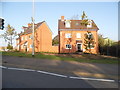
New houses on High Road, Shortstown
These are at the start of the new A600 bypass which goes round the village.
Image: © David Howard
Taken: 15 Oct 2017
0.22 miles
9
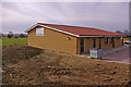
Shortstown Village Hall
The development of Shortstown started when Shorts Brothers established the Cardington airship works in 1917, to provide accommodation for the workers there (hence the name). The MOD took over the site in the 1920s, with Shortstown providing accommodation for RAF personnel. More recently new housing has been built alongside the original development, with further expansion planned for the other side of the A600 on the site of the disused airfield itself.
The Village Hall was built in 2007 to provide much needed community facilities. See Image for closeup of sign on the hall wall.
Image: © Ian Capper
Taken: 13 Mar 2008
0.23 miles
10
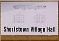
Shortstown Village Hall sign
See Image for background to Shortstown and its village hall. The images on the sign commemorate the close association of the village with the nearby airship works.
Image: © Ian Capper
Taken: 13 Mar 2008
0.23 miles