IMAGES TAKEN NEAR TO
Kathie Road, BEDFORD, MK42 0QH
Introduction
This page details the photographs taken nearby to Kathie Road, MK42 0QH by members of the Geograph project.
The Geograph project started in 2005 with the aim of publishing, organising and preserving representative images for every square kilometre of Great Britain, Ireland and the Isle of Man.

There are currently over 7.5m images from over14,400 individuals and you can help contribute to the project by visiting https://www.geograph.org.uk
Image Map
Images are licensed for reuse under creativecommons.org/licenses/by-sa/2.0
Notes
- Clicking on the map will re-center to the selected point.
- The higher the marker number, the further away the image location is from the centre of the postcode.
Image Listing (12 Images Found)
Images are licensed for reuse under creativecommons.org/licenses/by-sa/2.0
Image
Details
Distance
1
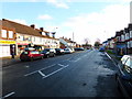
London Road, Bedford
From the corner of Cedar Road
Image: © David Howard
Taken: 1 Sep 2024
0.12 miles
3
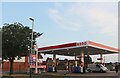
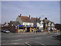
Esso petrol station on London Road, Bedford
Image: © David Howard
Taken: 1 Sep 2024
0.15 miles
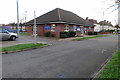
5
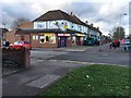
Mann's Supermarket, London Road, Bedford
Image: © PAUL FARMER
Taken: 24 Apr 2010
0.21 miles
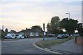
6
Pedestrian Crossing, London Road, Bedford
Image: © PAUL FARMER
Taken: 25 Dec 2010
0.22 miles
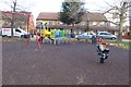
7
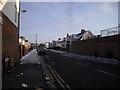
Fenlake Road, Bedford
Taken from the junction with London Road
Image: © PAUL FARMER
Taken: 25 Dec 2010
0.22 miles
9
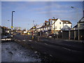
London Road, Bedford, Christmas Day 2016
Image: © PAUL FARMER
Taken: 25 Dec 2016
0.23 miles