IMAGES TAKEN NEAR TO
Banks Close, BEDFORD, MK42 0LL
Introduction
This page details the photographs taken nearby to Banks Close, MK42 0LL by members of the Geograph project.
The Geograph project started in 2005 with the aim of publishing, organising and preserving representative images for every square kilometre of Great Britain, Ireland and the Isle of Man.

There are currently over 7.5m images from over14,400 individuals and you can help contribute to the project by visiting https://www.geograph.org.uk
Image Map
Images are licensed for reuse under creativecommons.org/licenses/by-sa/2.0
Notes
- Clicking on the map will re-center to the selected point.
- The higher the marker number, the further away the image location is from the centre of the postcode.
Image Listing (2 Images Found)
Images are licensed for reuse under creativecommons.org/licenses/by-sa/2.0
Image
Details
Distance
1
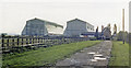
Cardington station (remains) and Airship Sheds, 1987
View SW, across the former ex-Midland Bedford (right) - Hitchin (left) line. The line was closed to passengers from 1/1/62, but may have remained open for goods until 1969. The station seems to be well preserved, still overshadowed by the Airship Sheds.
Image: © Ben Brooksbank
Taken: 16 Oct 1987
0.17 miles
2
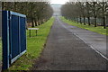
Paul Waller Avenue towards the Cardington Hangars
Image: © Philip Jeffrey
Taken: 21 Jan 2014
0.21 miles