IMAGES TAKEN NEAR TO
Alburgh Close, BEDFORD, MK42 0HF
Introduction
This page details the photographs taken nearby to Alburgh Close, MK42 0HF by members of the Geograph project.
The Geograph project started in 2005 with the aim of publishing, organising and preserving representative images for every square kilometre of Great Britain, Ireland and the Isle of Man.

There are currently over 7.5m images from over14,400 individuals and you can help contribute to the project by visiting https://www.geograph.org.uk
Image Map
Images are licensed for reuse under creativecommons.org/licenses/by-sa/2.0
Notes
- Clicking on the map will re-center to the selected point.
- The higher the marker number, the further away the image location is from the centre of the postcode.
Image Listing (4 Images Found)
Images are licensed for reuse under creativecommons.org/licenses/by-sa/2.0
Image
Details
Distance
2
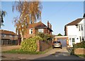
The Anchor Pub - Opposite Fenlake Meadows Nature Reserve
Image: © Jeff Tomlinson
Taken: 7 May 2007
0.14 miles
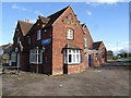
3
The outskirts of Bedford - Junction of Cardington Road and Eastcotts Road
Image: © Jeff Tomlinson
Taken: 7 May 2007
0.17 miles
4
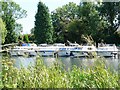
Bedford Boat club on the Great Ouse 2005
Bedford Boat club is located on the Great Ouse between Cardington lock and Duck Mill lock AKA Bedford lock. The club has existed since the early 50's and as can be seen only ever had a few boats and a slipway.I took this one in 2005 while taking a trip down memory lane with my folks.
Image: © Nick Goodey
Taken: 29 Aug 2005
0.18 miles