IMAGES TAKEN NEAR TO
Cardington Road, BEDFORD, MK42 0DA
Introduction
This page details the photographs taken nearby to Cardington Road, MK42 0DA by members of the Geograph project.
The Geograph project started in 2005 with the aim of publishing, organising and preserving representative images for every square kilometre of Great Britain, Ireland and the Isle of Man.

There are currently over 7.5m images from over14,400 individuals and you can help contribute to the project by visiting https://www.geograph.org.uk
Image Map
Images are licensed for reuse under creativecommons.org/licenses/by-sa/2.0
Notes
- Clicking on the map will re-center to the selected point.
- The higher the marker number, the further away the image location is from the centre of the postcode.
Image Listing (3 Images Found)
Images are licensed for reuse under creativecommons.org/licenses/by-sa/2.0
Image
Details
Distance
1
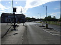
The outskirts of Bedford - Junction of Cardington Road and Eastcotts Road
Image: © Jeff Tomlinson
Taken: 7 May 2007
0.10 miles
2
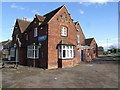
The Anchor Pub - Opposite Fenlake Meadows Nature Reserve
Image: © Jeff Tomlinson
Taken: 7 May 2007
0.12 miles
3
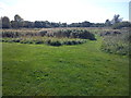
Path within Fenlake Meadows Local Nature Reserve
This path is part of a circular walk within Fenlake Meadows Local Nature Reserve in Bedford. The path leads away from the riverbank across the meadow towards a car park on Cardington Road.
Image: © Robert Kerr
Taken: 17 Sep 2011
0.21 miles