IMAGES TAKEN NEAR TO
Kingsbrook Road, BEDFORD, MK42 0BH
Introduction
This page details the photographs taken nearby to Kingsbrook Road, MK42 0BH by members of the Geograph project.
The Geograph project started in 2005 with the aim of publishing, organising and preserving representative images for every square kilometre of Great Britain, Ireland and the Isle of Man.

There are currently over 7.5m images from over14,400 individuals and you can help contribute to the project by visiting https://www.geograph.org.uk
Image Map
Images are licensed for reuse under creativecommons.org/licenses/by-sa/2.0
Notes
- Clicking on the map will re-center to the selected point.
- The higher the marker number, the further away the image location is from the centre of the postcode.
Image Listing (124 Images Found)
Images are licensed for reuse under creativecommons.org/licenses/by-sa/2.0
Image
Details
Distance

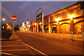
3

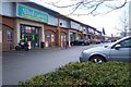
Costa in St Johns Retail Park, Bedford
Image: © David Howard
Taken: 30 Jan 2022
0.06 miles
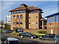
5
St Johns Retail Park
Perhaps places like this have caused the death of the High Street store.
Image: © Dennis simpson
Taken: 10 Mar 2008
0.08 miles