IMAGES TAKEN NEAR TO
Shallowford Grove, MILTON KEYNES, MK4 1ND
Introduction
This page details the photographs taken nearby to Shallowford Grove, MK4 1ND by members of the Geograph project.
The Geograph project started in 2005 with the aim of publishing, organising and preserving representative images for every square kilometre of Great Britain, Ireland and the Isle of Man.

There are currently over 7.5m images from over14,400 individuals and you can help contribute to the project by visiting https://www.geograph.org.uk
Image Map
Images are licensed for reuse under creativecommons.org/licenses/by-sa/2.0
Notes
- Clicking on the map will re-center to the selected point.
- The higher the marker number, the further away the image location is from the centre of the postcode.
Image Listing (84 Images Found)
Images are licensed for reuse under creativecommons.org/licenses/by-sa/2.0
Image
Details
Distance
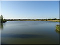
3
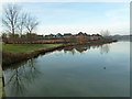
Time for reflection
Furzton Lake - a view of moorhens on the move rippling the reflection of the trees. Some of the properties now have solar arrays.
Image: © Malcolm Campbell
Taken: 13 Jan 2012
0.04 miles
4
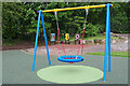
Children's play area in Furzton
The colourful swing has pride of place in this small play area - one of several in Furzton. Behind that is some artwork which may have been inspired by children's work. One of them says 'make it rain' which was certainly effective on this day of sunshine and showers.
Image: © Stephen McKay
Taken: 10 May 2023
0.06 miles
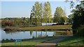
5
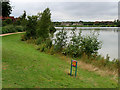
Furzton Lake, Southern Shore
Furzton Lake was created when the Furzton estate was being developed in the 1980s and incorporated a disused, water-filled clay pit. Its original purpose was as a “balancing lake” to hold floodwater in heavy rain. Since then, the lake and surrounding parkland has matured and developed into a recreation facility for joggers, cyclists and walkers with a series of paths and cycleways.
Image: © David Dixon
Taken: 5 Sep 2016
0.06 miles

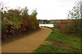
7
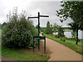
Path Round Furzton Lake
Furzton Lake was created when the Furzton estate was being developed in the 1980s and incorporated a disused, water-filled clay pit. Its original purpose was as a “balancing lake” to hold floodwater in heavy rain. Since then, the lake and surrounding parkland has matured and developed into a recreation facility for joggers, cyclists and walkers with a series of paths and cycleways.
Image: © David Dixon
Taken: 5 Sep 2016
0.07 miles
9

Pair of Great Crested Grebes feeding their youngster
See Image for details of Furzton Lake.
Image: © Cameraman
Taken: 5 Dec 2009
0.08 miles
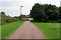
10
Furzton Lake, Milton Keynes
Furzton Lake was created in the eighties to act as a basin for flood waters during rainy spells. View from the bridge on National Cycle Route 51.
Image: © JThomas
Taken: 21 Sep 2019
0.08 miles