IMAGES TAKEN NEAR TO
Dulverton Drive, MILTON KEYNES, MK4 1DF
Introduction
This page details the photographs taken nearby to Dulverton Drive, MK4 1DF by members of the Geograph project.
The Geograph project started in 2005 with the aim of publishing, organising and preserving representative images for every square kilometre of Great Britain, Ireland and the Isle of Man.

There are currently over 7.5m images from over14,400 individuals and you can help contribute to the project by visiting https://www.geograph.org.uk
Image Map (Loading...)


Getting Data...Please wait
Leaflet Map data © OpenStreetMap
Images are licensed for reuse under creativecommons.org/licenses/by-sa/2.0
Notes
- Clicking on the map will re-center to the selected point.
- The higher the marker number, the further away the image location is from the centre of the postcode.
Image Listing (13 Images Found)
Images are licensed for reuse under creativecommons.org/licenses/by-sa/2.0
Image
Details
Distance
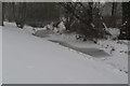
1
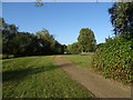
National Cycle Route 51, Tattenhoe Valley Park, Milton Keynes
Image: © JThomas
Taken: 21 Sep 2019
0.11 miles
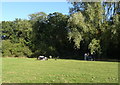
2
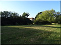
Green space, Tattenhoe Valley Park
Beside National Cycle Route 51, Milton Keynes.
Image: © JThomas
Taken: 21 Sep 2019
0.12 miles
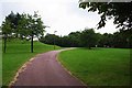
4
National Cycle Route 51, Tattenhoe Valley Park, Milton Keynes
Image: © JThomas
Taken: 21 Sep 2019
0.17 miles
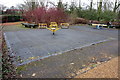
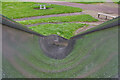
7

Children's slide at Furzton
The slide is always a favourite with children an this one with its downhill twist looks especially exciting. The surface is wet, however, following a rain shower.
Image: © Stephen McKay
Taken: 10 May 2023
0.17 miles
8
Children's slide at Furzton
This is the view down from the top of the slide seen in this view: Image It is covered in raindrops but it is easy to see why children might find this especially exciting.
Image: © Stephen McKay
Taken: 10 May 2023
0.17 miles
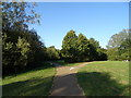
9
Path in Dulverton Drive Local Park, Dulverton Drive, Furzton, Milton Keynes
On the left can be seen part of a staggered mound which is topped by trees. Within the circle of trees is a wooden compass feature (not visible in this view). From the top of the mound the whole of the park can be viewed.
Image
Image: © P L Chadwick
Taken: 20 Jul 2014
0.24 miles
10
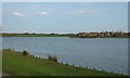
View of Furzton from Shenley Lodge bank of the lake.
Image: © Peter Roberts
Taken: 3 Apr 2005
0.24 miles