IMAGES TAKEN NEAR TO
Favell Drive, MILTON KEYNES, MK4 1AJ
Introduction
This page details the photographs taken nearby to Favell Drive, MK4 1AJ by members of the Geograph project.
The Geograph project started in 2005 with the aim of publishing, organising and preserving representative images for every square kilometre of Great Britain, Ireland and the Isle of Man.

There are currently over 7.5m images from over14,400 individuals and you can help contribute to the project by visiting https://www.geograph.org.uk
Image Map
Images are licensed for reuse under creativecommons.org/licenses/by-sa/2.0
Notes
- Clicking on the map will re-center to the selected point.
- The higher the marker number, the further away the image location is from the centre of the postcode.
Image Listing (16 Images Found)
Images are licensed for reuse under creativecommons.org/licenses/by-sa/2.0
Image
Details
Distance
1
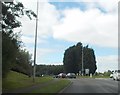
A421 approaching Elfield Park roundabout
Image: © John Firth
Taken: 22 Sep 2013
0.06 miles
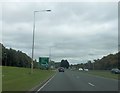
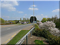
2
Standing Way Milton Keynes
Looking south-west from the roadside at Denbigh Hall.
Image: © Cameraman
Taken: 22 Apr 2010
0.11 miles
3
Standing Way, Milton Keynes
Taken from the roadside at Denbigh Hall and looking north-east towards the roundabout at the junction with Watling Street.
Image: © Cameraman
Taken: 22 Apr 2010
0.13 miles
4
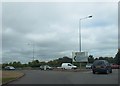
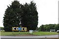
Elfield Park roundabout
Exit for Milton Keynes North
Image: © John Firth
Taken: 22 Sep 2013
0.14 miles
5
Old Milestone
Old milestone on what was the A.5 near to Bletchley, Milton Keynes. For overall view see http://www.geograph.org.uk/photo/5381001
Image: © Keith Evans
Taken: 22 Apr 2017
0.15 miles

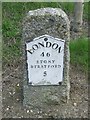
7
Milestone
Old milestone on what was the A5 near to Bletchley, Milton Keynes. For close up view see http://www.geograph.org.uk/photo/5380987
Image: © Keith Evans
Taken: 22 Apr 2017
0.15 miles
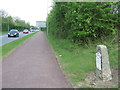
8
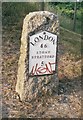
Old Milestone by the former A5 in Milton Keynes
Metal plate attached to stone post by the UC road (was A5), in parish of Woughton on the Green (Milton Keynes District), Watling Street; 100m West of roundabout with Standing Way, West of Redmoor, on cut grass bank where underpass for cycle track begins, on North side of road. Milton Keynes alloy plate (New), erected by the Holyhead Road (Hockliffe Division) turnpike trust in the 20th century.
Inscription reads:-
LONDON
46
STONY
STRATFORD
5
Milestone Society National ID: BU_LH46
Image: © A Rosevear & J Higgins
Taken: 11 Jul 2003
0.16 miles