IMAGES TAKEN NEAR TO
Braybrooke Drive, MILTON KEYNES, MK4 1AF
Introduction
This page details the photographs taken nearby to Braybrooke Drive, MK4 1AF by members of the Geograph project.
The Geograph project started in 2005 with the aim of publishing, organising and preserving representative images for every square kilometre of Great Britain, Ireland and the Isle of Man.

There are currently over 7.5m images from over14,400 individuals and you can help contribute to the project by visiting https://www.geograph.org.uk
Image Map
Images are licensed for reuse under creativecommons.org/licenses/by-sa/2.0
Notes
- Clicking on the map will re-center to the selected point.
- The higher the marker number, the further away the image location is from the centre of the postcode.
Image Listing (17 Images Found)
Images are licensed for reuse under creativecommons.org/licenses/by-sa/2.0
Image
Details
Distance
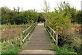
1
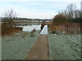
Frosty bridge
Foot bridge jutts out into the lake at this point - helpful for feeding wildlife.
Image: © Malcolm Campbell
Taken: 13 Jan 2012
0.15 miles
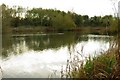
5
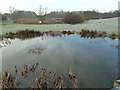
Pond and lake
Pond just below the bridge I was standing on provided the perfect foreground for another water shot of the lake.
Image: © Malcolm Campbell
Taken: 13 Jan 2012
0.17 miles
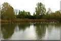
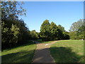
8
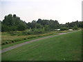
Furzton Lake
Looking out across the southern end of the lake on furzton
Image: © Mr Biz
Taken: 24 Jul 2006
0.21 miles
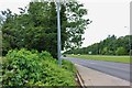
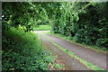
10
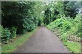
National Cycle Route 51, Tattenhoe Valley Park, Milton Keynes
Image: © JThomas
Taken: 21 Sep 2019
0.21 miles