IMAGES TAKEN NEAR TO
Aylesbury Road, BEDFORD, MK41 9RH
Introduction
This page details the photographs taken nearby to Aylesbury Road, MK41 9RH by members of the Geograph project.
The Geograph project started in 2005 with the aim of publishing, organising and preserving representative images for every square kilometre of Great Britain, Ireland and the Isle of Man.

There are currently over 7.5m images from over14,400 individuals and you can help contribute to the project by visiting https://www.geograph.org.uk
Image Map
Images are licensed for reuse under creativecommons.org/licenses/by-sa/2.0
Notes
- Clicking on the map will re-center to the selected point.
- The higher the marker number, the further away the image location is from the centre of the postcode.
Image Listing (6 Images Found)
Images are licensed for reuse under creativecommons.org/licenses/by-sa/2.0
Image
Details
Distance
1
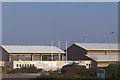
Bedford International Athletics Stadium
Now the home to major athletic events. Earlier in its career it only seemed to be used by the local schools!
Image: © Dennis simpson
Taken: 13 Feb 2008
0.22 miles
2
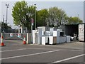
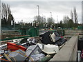
Barker's Lane Recycling Centre at Bedford
Image: © M J Richardson
Taken: 24 Apr 2010
0.22 miles
3
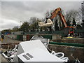
Barker's Lane Recycling Centre at Bedford
White goods depository.
Image: © M J Richardson
Taken: 24 Apr 2010
0.23 miles
4
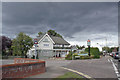
The White Horse pub, Bedford
Located in Newnham Avenue at the junction with Rosamond Road.
In the late 1960s/early 1970s, this pub was popular with students from the nearby Bedford College of Education (now University of Bedfordshire), as the college had no bar of its own at the time.
Image: © Richard Dorrell
Taken: 5 Oct 2019
0.23 miles
5
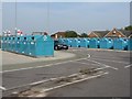
Recycling at Bedford
A smart and well-organised urban recycling centre in the eastern outskirts of Bedford.
Image: © M J Richardson
Taken: 15 Nov 2015
0.23 miles
6
Bedford household waste recycling centre
A smart and well-organised urban recycling centre in the eastern outskirts of Bedford.
Image: © M J Richardson
Taken: 15 Nov 2015
0.23 miles