IMAGES TAKEN NEAR TO
Pearmain Close, BEDFORD, MK41 9NH
Introduction
This page details the photographs taken nearby to Pearmain Close, MK41 9NH by members of the Geograph project.
The Geograph project started in 2005 with the aim of publishing, organising and preserving representative images for every square kilometre of Great Britain, Ireland and the Isle of Man.

There are currently over 7.5m images from over14,400 individuals and you can help contribute to the project by visiting https://www.geograph.org.uk
Image Map
Images are licensed for reuse under creativecommons.org/licenses/by-sa/2.0
Notes
- Clicking on the map will re-center to the selected point.
- The higher the marker number, the further away the image location is from the centre of the postcode.
Image Listing (14 Images Found)
Images are licensed for reuse under creativecommons.org/licenses/by-sa/2.0
Image
Details
Distance
1
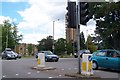
Polhill Campus
Part of De Montfort University. Photo taken from Newnham Ave, Bedford, looking across the junction with A428 (Goldington Road)
Image: © Dennis simpson
Taken: 28 May 2007
0.09 miles
2
Bedford College of Education, 1972
This is the view from under the entrance arch (the Porter's Lodge was on the right) into the main entrance courtyard of the college. The rooms on the left were mainly admin offices, with some lecture rooms on the upper floor.
The buildings are now the Polhill Campus of the University of Bedfordshire.
Image: © Richard Dorrell
Taken: Unknown
0.11 miles
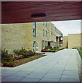
3
Polhill Campus, University of Bedfordshire
Image: © M J Richardson
Taken: 4 Dec 2008
0.11 miles
4
University of Bedfordshire
The Polhill Campus
Image: © M J Richardson
Taken: 4 Dec 2008
0.12 miles
5
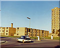
Bedford College of Education, 1972
This was the Bedford Teacher Training College, seen here from the junction between Polhill Avenue and Goldington Road. The college opened on this site in about 1966. The central block in this picture and the tower were student accommodation. The car is an MG 1100. My room was on the left on the 8th floor of the tower. Views from my room: Image] and Image
The college has now become part of the University of Bedfordshire, and the trees have grown a lot!
2019 image from approximately the same location: Image
Image: © Richard Dorrell
Taken: Unknown
0.12 miles
6
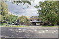
University of Bedfordshire, pedestrian entrance
In the late 1960s, when this building was Bedford College of Education, this was the main entrance to the college, and was un-gated. Today, a security pass is required to open the gates.
Looking through the entrance in 1972: Image
Image: © Richard Dorrell
Taken: 5 Oct 2019
0.13 miles
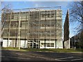
8
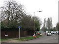
Road junction and university
Looking across Goldington Road towards Polhill Avenue. The buildings behind the trees are the older part of the University of Bedfordshire, Polhill Campus. They were built in the late 1960s, and at the time were Bedford College of Education. The trees were planted at the same time.
Image from approximately the same location, taken 1972: Image
Image: © Richard Dorrell
Taken: 5 Oct 2019
0.14 miles
9
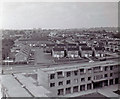
Bedford from the College Tower, 1971
A view over some of the buildings of Bedford College of Education and suburban Bedford, taken in 1971. The entrance arch to the college is bottom right. See also: Image The houses nearest are in Thurlestone Close.
Image: © Richard Dorrell
Taken: Unknown
0.14 miles
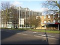
10
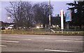
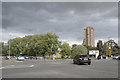
Goldington Road at the junction of Polhill Avenue
The University of Bedfordshire is on the right
Image: © David Howard
Taken: 30 Jan 2022
0.15 miles