IMAGES TAKEN NEAR TO
Chiltern Avenue, BEDFORD, MK41 9EQ
Introduction
This page details the photographs taken nearby to Chiltern Avenue, MK41 9EQ by members of the Geograph project.
The Geograph project started in 2005 with the aim of publishing, organising and preserving representative images for every square kilometre of Great Britain, Ireland and the Isle of Man.

There are currently over 7.5m images from over14,400 individuals and you can help contribute to the project by visiting https://www.geograph.org.uk
Image Map
Images are licensed for reuse under creativecommons.org/licenses/by-sa/2.0
Notes
- Clicking on the map will re-center to the selected point.
- The higher the marker number, the further away the image location is from the centre of the postcode.
Image Listing (13 Images Found)
Images are licensed for reuse under creativecommons.org/licenses/by-sa/2.0
Image
Details
Distance
3
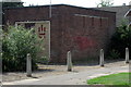
Electricity substation on Chiltern Avenue
Image: © Philip Jeffrey
Taken: 8 Aug 2013
0.07 miles

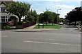
7
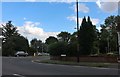
Park Avenue at the junction of Kimbolton Road
Image: © David Howard
Taken: 11 Jul 2020
0.19 miles
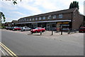
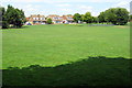
9
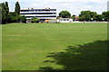
Newnham Middle School and playing fields
Image: © Philip Jeffrey
Taken: 8 Aug 2013
0.21 miles
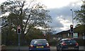
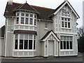
10
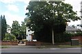
The Park pub, Bedford
Hiding behind the trees.
Image: © David Howard
Taken: 11 Jul 2020
0.21 miles