IMAGES TAKEN NEAR TO
Wentworth Drive, BEDFORD, MK41 8QE
Introduction
This page details the photographs taken nearby to Wentworth Drive, MK41 8QE by members of the Geograph project.
The Geograph project started in 2005 with the aim of publishing, organising and preserving representative images for every square kilometre of Great Britain, Ireland and the Isle of Man.

There are currently over 7.5m images from over14,400 individuals and you can help contribute to the project by visiting https://www.geograph.org.uk
Image Map
Images are licensed for reuse under creativecommons.org/licenses/by-sa/2.0
Notes
- Clicking on the map will re-center to the selected point.
- The higher the marker number, the further away the image location is from the centre of the postcode.
Image Listing (12 Images Found)
Images are licensed for reuse under creativecommons.org/licenses/by-sa/2.0
Image
Details
Distance
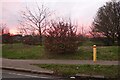
1
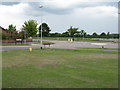
Roundabout at Woodside
At the junction of Wentworth Drive and Dover Crescent, on the northern fringe of Bedford.
Image: © M J Richardson
Taken: 23 Jun 2011
0.06 miles
2
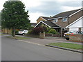
Dover Crescent, Woodside
The northern urban fringe of Bedford.
Image: © M J Richardson
Taken: 23 Jun 2011
0.07 miles
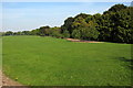
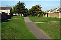
5
Park by Hookhams Lane, Salph End
Entering the urban area of Bedford
Image: © David Howard
Taken: 30 Jan 2022
0.14 miles
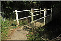
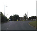
6
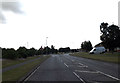
Wentworth Drive, Salph End
At the roundabout junction with Hookhams & Church Lanes
Image: © Geographer
Taken: 9 Aug 2014
0.16 miles
7
Roundabout on Hookhams Lane, Bedford
This is the first main road entering Bedford from this direction.
Image: © David Howard
Taken: 30 Jan 2022
0.16 miles
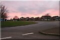
10
Norse Road Roundabout
At the junction with Norse Road, Hookhams & Church Lanes & Wentworth Drive
Image: © Geographer
Taken: 9 Aug 2014
0.21 miles