IMAGES TAKEN NEAR TO
Birkdale Road, BEDFORD, MK41 8AU
Introduction
This page details the photographs taken nearby to Birkdale Road, MK41 8AU by members of the Geograph project.
The Geograph project started in 2005 with the aim of publishing, organising and preserving representative images for every square kilometre of Great Britain, Ireland and the Isle of Man.

There are currently over 7.5m images from over14,400 individuals and you can help contribute to the project by visiting https://www.geograph.org.uk
Image Map
Images are licensed for reuse under creativecommons.org/licenses/by-sa/2.0
Notes
- Clicking on the map will re-center to the selected point.
- The higher the marker number, the further away the image location is from the centre of the postcode.
Image Listing (19 Images Found)
Images are licensed for reuse under creativecommons.org/licenses/by-sa/2.0
Image
Details
Distance
1
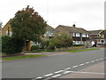
Houses on Rowallan Drive, Brickhill
A northern suburb of Bedford.
Image: © M J Richardson
Taken: 21 Sep 2017
0.06 miles
2
Lowther Road
Off Rowallan Drive, in the Brickhill/Putnoe area of Bedford.
Image: © M J Richardson
Taken: 21 Sep 2017
0.07 miles
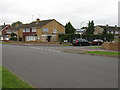
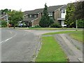
4
Parkstone Close, Bedford
From the junction with Wentworth Drive.
Image: © Rich Tea
Taken: 19 Jun 2009
0.12 miles
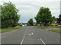
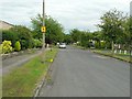
5
Birkdale Road, Bedford
And Troon Close, from Wentworth Drive.
Image: © Rich Tea
Taken: 19 Jun 2009
0.13 miles
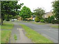
6
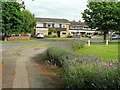
Parkstone Close, Bedford
With lavender in flower.
Image: © Rich Tea
Taken: 19 Jun 2009
0.17 miles
7
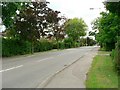
Kimbolton Road, Bedford
From the junction of Tamar Road.
As a child, I lived in the house behind the hedge on the left.
Image: © Rich Tea
Taken: 19 Jun 2009
0.20 miles
8
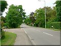
Kimbolton Road, Bedford
And the junction with Tamar Road.
Image: © Rich Tea
Taken: 19 Jun 2009
0.21 miles
10
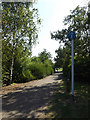
Path in Mowsbury Park
Off Wentworth Drive
Image: © Geographer
Taken: 8 Aug 2015
0.21 miles