IMAGES TAKEN NEAR TO
Park Road West, BEDFORD, MK41 7SL
Introduction
This page details the photographs taken nearby to Park Road West, MK41 7SL by members of the Geograph project.
The Geograph project started in 2005 with the aim of publishing, organising and preserving representative images for every square kilometre of Great Britain, Ireland and the Isle of Man.

There are currently over 7.5m images from over14,400 individuals and you can help contribute to the project by visiting https://www.geograph.org.uk
Image Map (Loading...)


Getting Data...Please wait
Leaflet Map data © OpenStreetMap
Images are licensed for reuse under creativecommons.org/licenses/by-sa/2.0
Notes
- Clicking on the map will re-center to the selected point.
- The higher the marker number, the further away the image location is from the centre of the postcode.
Image Listing (44 Images Found)
Images are licensed for reuse under creativecommons.org/licenses/by-sa/2.0
Image
Details
Distance
1

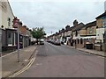
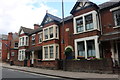
Park Road West, Bedford
Park Road West is a short residential road in Bedford.
Image: © Malc McDonald
Taken: 21 Jul 2018
0.01 miles
2
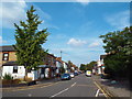
Palmerston Street, Bedford
View from Stanley Street along Palmerston Street.
Image: © N Avery
Taken: 28 Apr 2022
0.01 miles
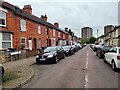
3
Park Road West, Bedford
Park Road West is a short residential street in Bedford.
Image: © Malc McDonald
Taken: 21 Jul 2018
0.03 miles
5
Garfield Street, Bedford
View from Stanley Street.
Image: © N Avery
Taken: 28 Apr 2022
0.07 miles
6
Terraced houses on Union Street, Bedford
Image: © David Howard
Taken: 11 Jul 2020
0.10 miles
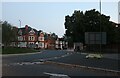
7
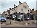
The Burnaby Arms, Stanley Street, Bedford
Public house on corner of Palmerston and Stanley Streets.
Image: © N Avery
Taken: 28 Apr 2022
0.11 miles
8
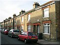
Gladstone Street, Bedford
Terraced cottages typical of the Black Tom area of Bedford.
Image: © N Avery
Taken: 25 Apr 2007
0.12 miles
9
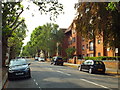
Warwick Avenue, Bedford
Warwick Avenue is a residential road in Bedford.
Image: © Malc McDonald
Taken: 21 Jul 2018
0.12 miles
10
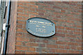
Plaque on former Bedford Training College
Detail of a plaque on a building at the junction of The Crescent and Tavistock Street.
Wider view of the building: Image
Image: © Richard Dorrell
Taken: 5 Oct 2019
0.14 miles