IMAGES TAKEN NEAR TO
Robin Hill, BEDFORD, MK41 7QP
Introduction
This page details the photographs taken nearby to Robin Hill, MK41 7QP by members of the Geograph project.
The Geograph project started in 2005 with the aim of publishing, organising and preserving representative images for every square kilometre of Great Britain, Ireland and the Isle of Man.

There are currently over 7.5m images from over14,400 individuals and you can help contribute to the project by visiting https://www.geograph.org.uk
Image Map
Images are licensed for reuse under creativecommons.org/licenses/by-sa/2.0
Notes
- Clicking on the map will re-center to the selected point.
- The higher the marker number, the further away the image location is from the centre of the postcode.
Image Listing (4 Images Found)
Images are licensed for reuse under creativecommons.org/licenses/by-sa/2.0
Image
Details
Distance
2
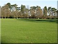
Bedford Park
With a Green Flag award in 2007, this Victorian town park is one of Bedford's open spaces, with some fine trees on its boundary.
Image: © M J Richardson
Taken: 6 Dec 2008
0.20 miles
3
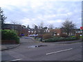
Emerald Court, Brickhill Drive
These buildings were formerly part of Pilgrim School - a grammar school that became a comprehensive but was eventually closed in the early'80s because of a surplus of upper schools in the town. Now providing office accommodation, current occupants include the Registry Office.
Image: © Fred Round
Taken: 15 Jan 2007
0.21 miles